
Machine Learning-Based Land Cover Classification and Environmental Change Detection for Dam Monitoring at Suleja Dam Using Remote Sensing Data
DOI:
https://doi.org/10.70882/josrar.2026.v3i4.242Keywords:
Dam monitoring, Machine learning, Remote sensing, Random Forest, NDVI, NDWIAbstract
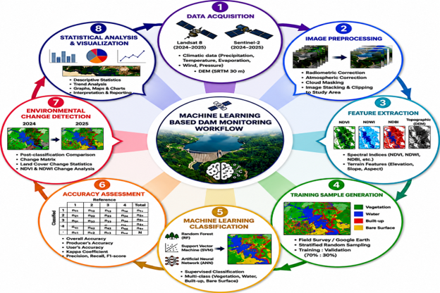
Effective dam monitoring is essential for sustainable water resource management and environmental protection. This study integrates machine learning, remote sensing, and Geographic Information Systems (GIS) to assess environmental changes within the Suleja Dam catchment, Nigeria. Multi-temporal Landsat 8 and Sentinel-2 imagery acquired between May and October of 2024 and 2025, together with climatic variables including precipitation, surface temperature, soil moisture, evaporation, and terrain data, were analyzed to evaluate land-cover dynamics. The Normalized Difference Vegetation Index (NDVI) and Normalized Difference Water Index (NDWI) were used to monitor vegetation and surface water changes, while Random Forest (RF), Support Vector Machine (SVM), and Artificial Neural Network (ANN) classifiers were employed for land-cover classification. Classification performance was evaluated using confusion matrices and standard accuracy metrics. RF achieved the highest overall accuracy (92.83%; Kappa = 0.904), outperforming SVM (88.67%; Kappa = 0.849) and ANN (85.00%; Kappa = 0.800). Environmental change detection revealed a 6.5% decline in vegetation cover and increases in built-up areas (5.8%), water extent (3.2%), and bare surfaces (2.1%). The results demonstrate that integrating machine learning with remote sensing provides a robust and cost-effective framework for continuous dam monitoring, environmental change detection, and sustainable watershed management.
References
Adeboboye, A. J., Atoki, L. O. and Agada, A. S. (2024). Flood Vulnerability Mapping Using GIS and Remote Sensing. International Journal of Multidisciplinary Research and Growth Evaluation, 5(03). https://doi.org/10.5281/zenodo.12702664
Aleksandra, K. and Jan, B. (2025). Remote Sensing Perspective on Monitoring and Predicting Underground Energy Sources Storage Environmental Impacts: Literature Review. Remote Sensing, 17(15), 2628; https://doi.org/10.3390/rs17152628
Belgiu, M., & Drăguţ, L. (2016). Random forest in remote sensing: A review of applications and future directions. ISPRS Journal of Photogrammetry and Remote Sensing, 114, 24–31. https://doi.org/10.1016/j.isprsjprs.2016.01.011
Breiman, L. (2001). Random forests. Machine Learning, 45(1), 5–32.
Chen, Y., Li, X., & Zhao, H. (2022). Deep learning-based dam deformation monitoring using remote sensing data. Remote Sensing, 14(8), 1765.
Chang, S. T., Lin, S. Y., Lin, Y. C. (2025). Deep learning-based surface deformation tracking with interferometric fringes: A case study in Taiwan. International Journal of Applied Earth Observation and Geoinformation, 143, https://doi.org/104796.10.1016/j.jag.2025.104796
Chen, L., Liu, L., Liu, S., Shi. Z. and Shi, C. (2025). The Application of Remote Sensing Technology in Inland Water Quality Monitoring and Water Environment Science: Recent Progress and Perspectives. Remote Sensing, 17(4), 667; https://doi.org/10.3390/rs17040667
European Space Agency (2023). Sentinel satellite missions for Earth observation and environmental monitoring. ESA Publications.
Foley, J. A., Defries, R. S., Asner, G. P., Barford, C. C., Bonan, G., Carpenter, S. R., Chapin, F. S., Coe, M. T., Daily, G. C., Gibbs, H., Helkowski, J. H., Holloway, T., Howard, E., Kucharik, C. J., Monfreda, C., Patz, P., Prentice, I. C., Ramankutty, N., and Snyder, P. K. (2005). Global consequences of land use. Science, 309(5734), 570–574. https://doi.org/10.1126/science.1111772
Giulio C., Luigi P., Ruth Q., Jeroen A., Paul E., Maurits E., Stephen H., Walter L. F., Natalia L., Bongani M., Doug G. N., Keziah N., Nobubelo N., Allison P., Cate R., Josep D. T., Lorenzo V., Jessica A. E. and Elena B. (2022). Sand Dams for Sustainable Water Management: Challenges and Future Opportunities. SSRN Electronic Journal, https://doi.org/10.2139/ssrn.3998987
ICOLD (2021). Dam Safety Guidelines and Monitoring Practices. International Commission on Large Dams.
Lambin, E. F., & Geist, H. J. (2006). Land-Use and Land-Cover Change: Local Processes and Global Impacts. Springer.
Li, J., Wang, S., & Liu, P. (2021). Remote sensing applications in reservoir and dam monitoring: A review. Water Resources Management, 35(7), 2135–2150.
Li, Y., Zhang, H., Yang, Z., Cao, Y. and Su. Y. (2024). Research and Application of Dam Safety Monitoring Information Management System Based on GIS Platform. Proceedings of Conference on Sustainable Traffic and Transportation Engineering in 2023. https://doi.org/10.1007/978-981-97-5814-2_49
Ma, C., Xu, X., Yang, J. and Cheng, L. (2023). Safety Monitoring and Management of Reservoir and Dams. Water, 15(6), 1078; https://doi.org/10.3390/w15061078
Maxwell, A. E., Warner, T. A., & Fang, F. (2018). Implementation of machine-learning classification in remote sensing: An applied review. International Journal of Remote Sensing, 39(9), 2784–2817. https://doi.org/10.1080/01431161.2018.1433343
McFeeters, S. K. (1996). The use of the normalized difference water index (NDWI) in the delineation of open water features. International Journal of Remote Sensing, 17(7), 1425–1432.
Myung, S. C. and Jiaguo, Q. (2025). Remote sensing-based assessment of dam impacts on hydrology, geomorphology, ecosystems, and society – a review. Environmental Earth Sciences 84(12):1-20. https://doi.org/10.1007/s12665-025-12345-7
Pettorelli, N., Vik, J. O., Mysterud, A., Gaillard, J.-M., Tucker, C. J., & Stenseth, N. C. (2005). Using the satellite-derived NDVI to assess ecological responses to environmental change. Trends in Ecology & Evolution, 20(9), 503–510. https://doi.org/10.1016/j.tree.2005.05.011
Rouse, J. W., Haas, R. H., Schell, J. A., & Deering, D. W. (1974). Monitoring vegetation systems in the Great Plains with ERTS. Third Earth Resources Technology Satellite-1 Symposium, NASA SP-351, 309–317.
Swapna A. J., Khalid M. A. (2024). Remote Sensing Techniques for Water Quality Monitoring: A Review. Sensors, 24(24):8041. https://doi.org/10.3390/s24248041
Yan S., Jiayuan F., Weiwei L., Chuan L., Xiaohe L., and Xiudong X. (2025). Dam Deformation Monitoring Model Based on Deep Learning and Split Conformal Quantile Prediction. Applied Science, 15(4), 1960; https://doi.org/10.3390/app15041960
Zhang, H., Zhou, L., & Wu, J. (2024). Artificial intelligence applications in infrastructure and dam monitoring. Engineering Applications of Artificial Intelligence, 128, 107534.
Downloads
Published
Issue
Section
License
Copyright (c) 2026 Lucas Olu Atoki (Author)

This work is licensed under a Creative Commons Attribution-NonCommercial 4.0 International License.
- Attribution — You must give appropriate credit, provide a link to the license, and indicate if changes were made. You may do so in any reasonable manner, but not in any way that suggests the licensor endorses you or your use.
- NonCommercial — You may not use the material for commercial purposes.
- No additional restrictions — You may not apply legal terms or technological measures that legally restrict others from doing anything the license permits.