
Investigation of Earth Tremor Occurrences in Nigeria Using Shuttle Radar Topographic Mission (SRTM) Data and Aeromagnetic Data
DOI:
https://doi.org/10.70882/josrar.2025.v2i5.117Keywords:
Earth tremor, Curie point depth, Seismic hazard, TectonicAbstract
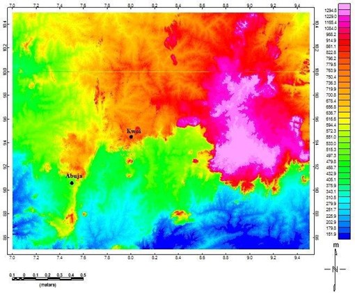
Earth tremors, though often low in magnitude, represent critical indicators of crustal instability and potential seismic hazards. Nigeria, traditionally considered a region of low seismic risk, has recorded recur3rent tremor events across the northcentral and southwestern regions, raising questions about the tectonic and geodynamic processes driving these disturbances. Thisa study integrates Shuttle Radar Topographic Mission (SRTM) data with aeromagnetic datasets to investigate the relationship between surface lineaments, subsurface structures, and tremor occurrences in these regions. SRTM analysis reveals that most tremor epicenters occur near elevated terrains, where topographic loading and structural complexity enhance seismic susceptibility. Aeromagnetic interpretations using tilt derivative techniques delineate major and minor fault systems, showing that tremors in Abuja and Kwoi align with a major NE–SW fault system linked to the offshore Romanche fracture zone, while those in the southwest are associated with intersecting NE- and NW-trending fractures. Curie Point Depth (CPD) estimates further highlight lithospheric thinning in the northcentral region (1.6–13 km), likely influenced by plume dynamics associated with the St. Helena hotspot, in contrast to deeper CPD values (7.2–13 km) in the southwest, reflecting far-field plate stresses. The results demonstrate that Nigeria’s seismicity is driven by a combination of plume-related magmatism, lithospheric weakness, and far-field tectonic forces. These findings provide a preliminary geophysical framework for understanding tremor genesis in intraplate settings and underscore the need for improved seismic monitoring and hazard preparedness in Nigeria.
References
Ahmad Adib and Pooria Kianoush (2025). Enhanced seismic hazard assessment and risk zoning in the Kashan Region, Central Iran: Insights from historical data and advanced modeling techniques. Results in Earth Sciences, 3; 100098. https://doi.org/10.1016/j.rines.2025.100098
Akpan O. U. and Tahir Abubakar Yakubu (2010). A review of earthquake occurrences and observations in Nigeria. Earthq. Sci, 23: 289 – 294. https://doi.org/10.1007/s11589-010-0725-7
Bello Y Ayoola, Mohammed B Yakubu and Muhammad A Bilal (2024). Delineating Potential Hydrocarbon Targets Through Aero-Radiometric Techniques. PHYSICSAccess, 4(2); 116– 125. https://doi.org/10.47514/phyaccess.2024.4.2.014
Bello Y.A., Lawal, K.M., Magaji, S.S., Raimi J., Amuda, T.O., Daramola D., Yakubu M.B. and Lawal, H.A. (2025a). Investigating the connectivity of Geshere and Rishiwa younger granite using aero-radiometric data. Proceedings of the Nigerian Society of Physical Sciences, 2(151). https://doi.org/10.61298/pnspsc.2025.2.151
Bello, Y.A., Evans, S.C., Lawal, H.A., Alao, J.O., Daramola D., Amuda T.O., Yakubu M.B. and Hussaini, S.M. (2025b). Investigating hydrothermal alteration associated with gold mineralization in Birnin-Gwari through transformation of aero-radiometric data. Proceedings of the Nigerian Society of Physical Sciences 2(171). https://doi.org/10.61298/pnspsc.2025.2.171
Blakely, R.J. (1995) Potential Theory in Gravity & Magnetic Applications. Cambridge University Press, Cambridge. http://dx.doi.org/10.1017/CBO9780511549816
Coulon, C., Vidal, P., Dupuy, C., Baudin, P., Popoff, M., Maluski, H., & Hermitte, D. (1996). The Mesozoic to Early Cenozoic Magmatism of the Benue Trough (Nigeria): Geochemical Evidence for the Involvement of the St Helena Plume. Journal of Petrology, 37(6), 1341–1358.
Dasho O. A., Emmanuel A. Ariyibi, Adebiyi S. Adebayo and Sesan C. Falade (2020). Seismotectonic lineament mapping over parts of Togo-Benin-Nigeria shield. NRIAG Journal of Astronomy and Geophysics, 9(1); p 539 – 547. https://doi.org/10.1080/20909977.2020.1797427
Ebinger, C. J. Keir, D., Bastow, I. D., Whaler, K., Hammond, J. O. S., Ayele, A., Miller, M. S. Tiberi, C. and Hautot, S. (2017). Crustal Structure of Active Deformation Zones in Africa: Implications for Global Crustal Processes. Tectonics, 36, 3298 – 3332. https://doi.org/10.1002/2017TC004526
Eludoyin, A.O., Olusola, A., Fashae, O.A., Jeje, L.K., Faniran, A. (2023). Geology and Landscapes of the Southwestern Nigeria. In: Faniran, A., Jeje, L.k., Fashae, O.A., Olusola, A.O. (eds) Landscapes and Landforms of Nigeria. World Geomorphological Landscapes. Springer, Cham. https://doi.org/10.1007/978-3-031-17972-3_14
Fayez Harash and Chao Chen (2022). Determination of Curie Point Depth Distribution and Heat Flow Regime Characteristics in Eratosthenes Seamount, Eastern Mediterranean Sea. Energies, 15(22), 8634; https://doi.org/10.3390/en15228634
Goki, N. G., Onwuka, S. A., Oleka, A. B., Iyakwari, S., Tanko, I. Y., Kana, A. A., Umbugadu, A. U., & Usman, H. O. (2020). “Preliminary geological evidence for multiple tremors in Kwoi, Central Nigeria.” Geoenvironmental Disasters, 7(1), Article 22. https://doi.org/10.1186/s40677-020-00156-w
Goki N. G., Solomon Anayo Onwuka, Adama Baba Oleka, Shekwoyandu Iyakwari, Ishak Yau Tanko, Aisha Abubakar Kana, Allu Augustine Umbugadu and Halima Osu Usman (2020). Preliminary geological evidence for multiple tremors in Kwoi, Central Nigeria. Geoenvironmental Disasters, 7: 22 https://doi.org/10.1186/s40677-020-00156-w
Hilemichaeil S., Tigistu Haile and Gezahegn Yirgu (2024). Curie point depth, thermal gradient and heat low along the Ethiopia Rift System and adjacent plateaus using spectral evaluation approach: implications for geothermal resources. Geothermal Energy, 12; 13. https://doi.org/10.1186/s40517-024-00291-9
Mishra M., Dinoj Kumar Upadhyay and Shailendra Kumar Mishra (2012). Establishing climate information service system for climate change adaptation in Himalayan region. CURRENT SCIENCE, VOL. 103(12).
Muhammad B Atif, Yongzhi Wang, Muhammad P Akhter, Bello Y Ayoola, Lawal K Muideen, Fahad Hameed, Kateryna Hlyniana, Bo Wen, Zubair Nabi, Dong Yuhao and Yakubu M Bashir (2025). Delineating Hot Zone and Lineaments within Vredefort Crater in South Africa through Aeromagnetic Data Inversions. PHYSICSAccess, 5(1). https://doi.org/10.47514/phyaccess.2025.5.1.001
Okunlola O. A. Oluwabusayo Mary Ajibola, Olusegun Gbenga Olisa (2022). Rare Earth Element Geochemistry and Abundances in Syenites and Charnockitic Rocks of Selected Locations within Southwestern Nigeria. RMZ – M&G, 68[3] pp. 1 – 10. https://doi.org/10.2478/rmzmag-2021-0018
Oluwafemi, O. A., Muhammad, M. U., & Yakubu, T. A. (2017). Journal of Global Resources, 5, 101–108.
Omeje M., Husin W., Noorddin I., Oha I.A., Onwuka O.S, Ugwuoke P.E. and Meludu O. (2013). Geoelectrical investigation of aquifer problems in Gosa area of Abuja, North Central, Nigeria. International Journal of Physical Sciences, 8(13), 549 – 559. https://doi.org/10.5897/IJPS12.600
Ostapenko, H., Zatserkovnyi V. and de Donatis, M. (2022). Analysis of the correlation between lineaments and earthquake epicenters in the Marche region (Italy) using remote sensing tools. 16th International Conference Monitoring of Geological Processes and Ecological Condition of the Environment, Kyiv, Ukraine, p.1 – 5. https://doi.org/10.3997/2214-4609.2022580054
Oyinloye A. O. (2011). Geology and Geotectonic Setting of the Basement Complex Rocks in South Western Nigeria: Implications on Provenance and Evolution, Earth and Environmental Sciences, Dr. Imran Ahmad Dar (Ed.), ISBN: 978-953-307-468-9.
Oyibo David and Kadiri Afegbua Umar (2023). EARTH TREMORS - EMERGING THREATS IN NORTHERN NIGERIA. FUDMA Journal of Sciences (FJS), 7(6); 1 – 7. DOI: https://doi.org/10.33003/fjs-2023-0706-2093
Oyibo David, Omali Aurelius Ojaina, Kadiri Umar Afegbua and Iduma Kelvin Uche (2022). Geophysical Evaluation of Central Nigeria Earth Tremor Activities using High Resolution Airborne Magnetic Data. Advances in Research, 23(2); 23 – 38. https://doi.org/10.9734/AIR/2022/v23i230327
Salem, A., Green, C. Ravat, D., Singh, K. H., East, P., Fairhead, J. D., Mogren S. and Biegert
E. (2014). Depth to Curie temperature across the central Red Sea from magnetic data using the de-fractal method. Technophysics., vol. 624–625, pp. 75 – 86, 2014. https://doi.org/10.1016/j.tecto.2014.04.027
Shuaibu, A., Alile, O.M., Aigbogun, C.O., Ighodalo, J.E. and Bello, Y.A. (2022). Thermal Characterization of the Pb-Zn Bearing Zone in the Lower Benue Trough of Nigeria Through the Curie Point Depth, Geothermal Gradient, and Heat Flow. Book of Proceedings of the 1st Faculty of Science International Conference FSIC, Air Force Institute of Technology, Kaduna Nigeria. p294 – 300. ISBN:9789787946589
Tanaka, A., Okubo, Y. and Matsubayashi, O. (1999). Curie point depth based on spectrum analysis of the magnetic anomaly data in East and Southeast Asia. Tectonophysics, 306(3 – 4); p 461 – 470. https://doi.org/10.1016/S0040-1951(99)00072-4
Vijaya Rao V. and Damodara Nara (2022). Constraints on the lithospheric structure and tectonics of Archean Dharwar Craton, southern India from geophysical and geological data: Evidence for modified lithosphere. Geosystems and Geoenvironment, 1; 100071. https://doi.org/10.1016/j.geogeo.2022.100071.
Downloads
Published
Issue
Section
License
Copyright (c) 2025 Journal of Science Research and Reviews

This work is licensed under a Creative Commons Attribution-NonCommercial 4.0 International License.
- Attribution — You must give appropriate credit, provide a link to the license, and indicate if changes were made. You may do so in any reasonable manner, but not in any way that suggests the licensor endorses you or your use.
- NonCommercial — You may not use the material for commercial purposes.
- No additional restrictions — You may not apply legal terms or technological measures that legally restrict others from doing anything the license permits.

